Digital Twin VR allows users to explore real-scale 3D mesh models and location-based panoramic scenes in a fully immersive virtual reality environment. Features like minimap, teleportation, POI (Point of Interest), and automated tours make navigation faster and more intuitive.
Digital Twin VR: Interactive Virtual Experience with 3D Mesh and Panorama
Organizations can digitize physical environments to improve decision-making, reduce operational costs, and increase traceability. Today, users are not only searching for "digital twin" concepts but also how to experience them in Virtual Reality (VR). Combining digital twin technology with Geographic Information Systems (GIS) enables location-based data management, scenario analysis, and real-scale visualization of environments.
As part of Intelli Software, OrbitraVR and VisuterraVR extend the digital twin concept beyond visualization. These applications transform digital twins into interactive systems with user navigation, POI management, and immersive exploration capabilities.
OrbitraVR: Interactive 3D Mesh Virtual Environment
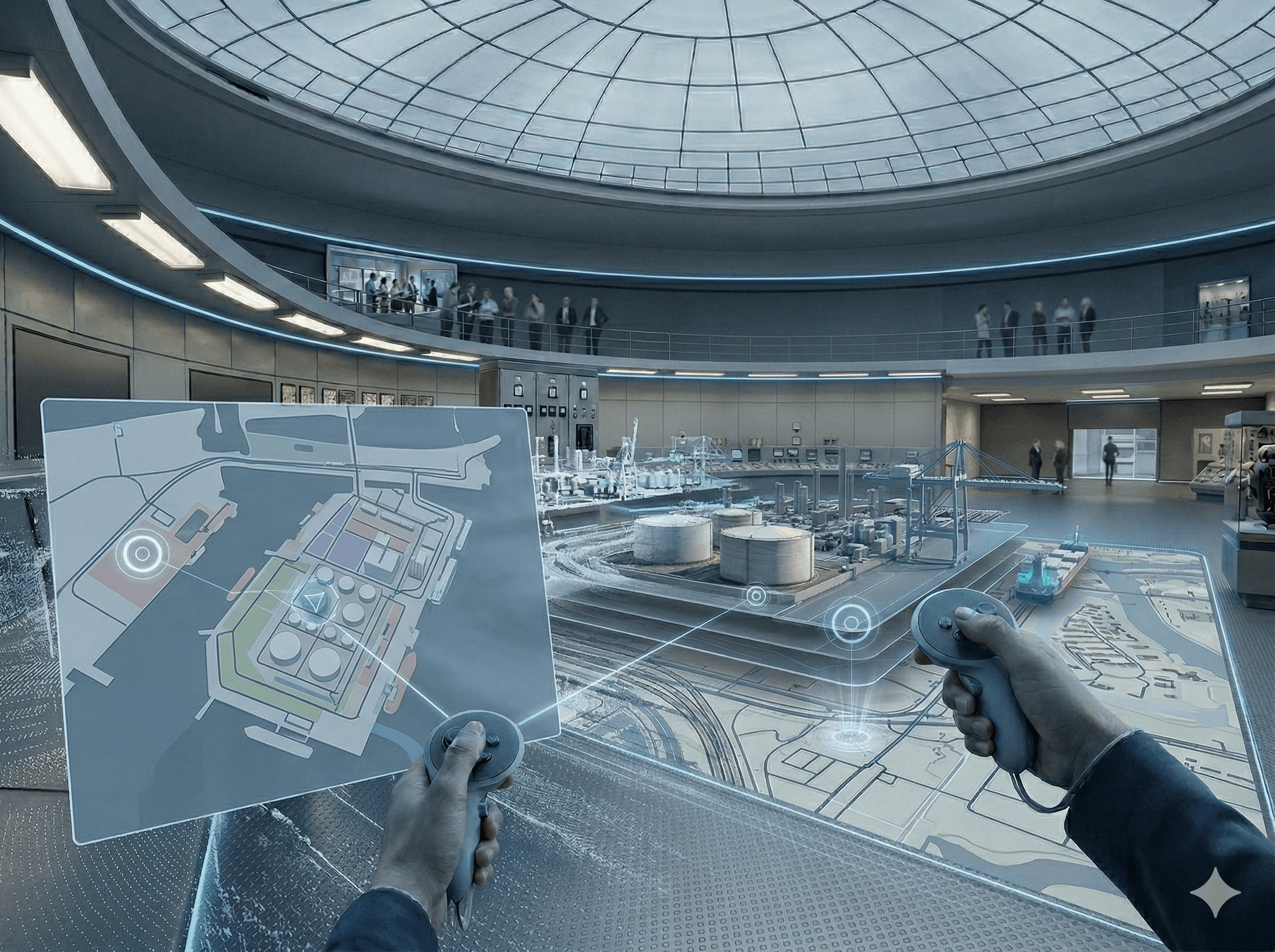
3D mesh models are integrated into OrbitraVR to create fully interactive environments. Users can move freely within the scene using a first-person perspective and experience spaces at real scale. This approach is highly valuable for urban planning, campus design, industrial zones, and facility management.
OrbitraVR includes teleportation features that allow users to quickly navigate to predefined locations. A top-down view option enables users to analyze the overall layout from a bird’s-eye perspective, supporting faster and more accurate planning decisions.
VisuterraVR: Panorama-Based Navigation with Location Awareness
VisuterraVR combines panoramic imagery with spatial positioning and orientation data, enabling users to explore real-world environments in VR. Navigation between scenes can be done via interactive hotspots or POI lists.
Information points can include audio content that plays automatically when activated. This makes the application suitable for training, guided tours, field inspections, and operational standardization. Zoom functionality allows users to examine distant details within panoramic scenes.
Why Digital Twin and VR Matter
Keeping data accurate and up-to-date is critical for digital twin systems. GIS infrastructure enables classification, querying, and analysis of spatial data. VR transforms this data into an understandable and interactive experience where users can explore environments, access critical points, and accelerate decision-making processes.
Technologies such as 3D modeling, point clouds, simulation, and data visualization enhance the effectiveness of VR-based digital twin systems. Navigating real-world environments in VR significantly improves planning, maintenance, and validation workflows.
New Features: Navigation, Minimap, and Control
Recent updates in VisuterraVR focus on usability and real-world applications:
Minimap: A dynamic map that appears when looking down.
Minimap zoom: Adaptive zoom levels with dynamic loading.
Teleportation via map: Instantly navigate to selected locations.
Automated tour mode: Predefined routes with speed control and audio guidance.
Control panel: Centralized menu for navigation and interaction features.
These features transform VR from a demonstration tool into a scalable solution integrated into daily workflows.
Faster Exploration and Better Decisions with Digital Twin VR
GIS simplifies data management, while VR makes data accessible and actionable. With OrbitraVR, users can explore real-scale 3D environments. With VisuterraVR, they can analyze aligned panoramic scenes and navigate efficiently using minimap and automation tools.
Contact the Intelli Software team to explore how Digital Twin VR solutions can be adapted to your use case and improve your operational workflows.